
The Afar Depression: Ethiopia
The Geology of Afar Region: How the Africa Continental Plate is Splitting, the Formation of a New Ocean and the Hottest Place on Earth
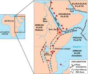 Afar depression also know as Afar Triangle or Danakil Depression (Danakil is located in the northern part of the Afar depression) is a geological depression resulting from a tectonic triple-rifts junction (the Afar Triple Junction). The depression lies near the Horn of Africa, overlapping Eritrea, Djibouti, and the Afar Region of Ethiopia (this occurs near Lake Abbe). At this junction, ridges that form the Red Sea and the Gulf of Aden emerge on land and meet the East African Rift. This makes Afar Depression among the two places on earth where a mid-ocean ridge can be studied on land (other one occurs in Iceland).
What makes the study of the depression interesting is that along each of the three rifts, the Earth’s crust is spreading apart at an annual rate of about 0.3-0.8 inches (1-2 centimeters), this is believed to be happening through the entire 6,000km length of the East Africa Rift (from the Afar Triangle to Mozambique); which means that African plate is slowly splitting into the Nubian and Somalian plates. When divergent boundaries form within continents, they eventually open up and become ocean basins, which is a clear case in the region. Geologists believe that in about 10 million years, the Red Sea will break through the coastal highlands and flood the Afar Depression and the entire East Africa Rift creating a new ocean (larger than the red sea), making the Horn of Africa a large island.
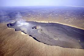
The geology of the Afar region is fascinating; the floor of the Depression is composed mostly of basaltic lava. One of earth’s five lava lakes and one of the greatest active volcanoes, Erta Ale is found here, as well as Dabbahu Volcano. Geologists believe that the Afar Depression is underlain by a mantle plume, a great upwelling of mantle that melts to yield basalt as it approaches the surface. The youngest volcano in the region, Dollol volcano first erupted in 1926.
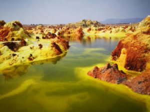
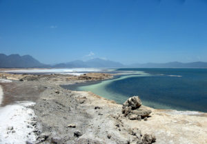
This area is actively volcanic, and produces formidable and colorful landscapes. As the plates drift apart, the crust above them thins and cracks, allowing magma to push to the surface through the thin spots and warm underwater springs. This is accompanied by series of earthquakes and formation of deep fissures in the terrain running for hundreds of metres and sinking of valley floor across the Depression. In September and October 2005 alone, a total of 163 earthquakes of magnitudes greater than 3.9 and a volcanic eruption occurred within the Afar rift at the Dabbahu and Erta Ale volcanoes. The region is home to more than thirty young volcanoes, sulphurous yellow hot springs and salt plains. As the boiling water bubble up to the surface, they deposit the dissolved calcium carbonates creating towering chimneys. Some of these chimneys reach heights of 50 meters, and puffs of steam vent from the top. Sulphur, other minerals and possibly thermopylae bacteria cause spectacular colors. The low elevation of the region allowed the Red Sea to periodically flood into the Depression, leaving behind salt ‘white gold’ from the evaporated seawater; the latest flood is estimated to have occurred roughly 30,000 years ago.
The northern lowlands of the Afar Depression (Dallol settlement) are dominated by heat and drought. It is the hottest inhabited place on earth in terms of year-round average temperatures at around 34°C (94°F) and daytime temperatures often reaching 50°C. The Danakil depression is also one of the lowest places on the planet lying at about 116m below the sea level (at the lowest point). As the tectonic plates underlying the depression continue to slowly move apart, the land will continue to drop farther below sea level.
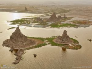
The Awash River, which is within Ethiopia boundaries, is the only major river that flows into the Depression. It dries up in a chain of salt lakes, where its water evaporates as quickly as it is supplied due to high temperature. Lakes in the region include: Lake Abbe which is fed by the Awash River together with some few seasonal streams on the west and south. Diversion of water from Awash River for irrigation has caused the lake to shrink by nearly two-thirds from its original size. Another lake is Lake Assal which is a crater lake in central Djibouti and one of the most saline water bodies on earth with salt concentration of 35% going up to 40%. The lake is fed by very saline hot springs. Salt mining is a major economic activity in the area, favored by high evaporation rate of water due to high temperature. Lake Assal lies 155m below sea level, making it the lowest point on land
in Africa and the third-lowest point on Earth after the Sea of Galilee and the Dead Sea. Other lakes include Lake Afrera, Lake Kuram among others.
The Middle Awash is widely known as the cradle of hominids due to numerous discoveries of fossil hominid at Gona (site of the world’s oldest stone tools) and Hadar (site of the famous fossilized specimen of “Lucy” Australopithecus afarensis). The “Lucy” fossil was discovered by a team lead by Donald Johanson in 1974 and has been dated 3.2 million years old.
Extremophiles; organisms that thrive in extreme conditions like high temperatures, toxic gases, high metal concentrations and high salinity and acidity are currently being studied in the area; which is a scientific breakthrough in quest to find life in areas with extreme conditions in the solar system.
Your article is really helpful. thnks…